 |
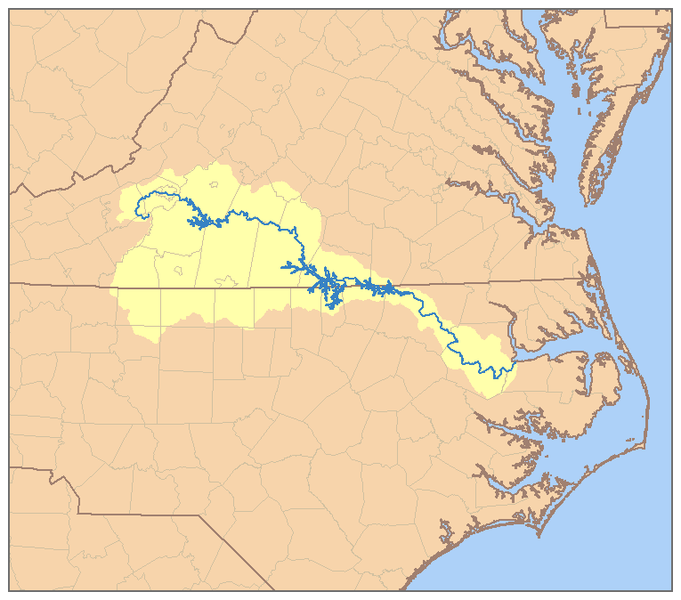
| Roanoke River Watershed Map Sourced from: http://en.wikipedia.org/wiki/File:RoanokeRiverWatershed.png
The USGS
Geographic Names Information System includes many historical names that the
Roanoke River has gone by including; Hocomawananch, an Indian name; Roenock by
the European settlers in 1670. It has been labeled as Occaneechi River on Col.
Cadwallader Jones’ map; and named as Staunton River on a 1727 survey map of the
VA-NC state boundary line. The Native Indians and early explorers knew the
infamous river as the “River of Death” due to spring floods that had taken many
lives. The flood plain as it runs through North Carolina spans widths as wide
as 5 miles (NCEE, 2013). After severe flooding in the 1940’s, several dam and reservoir
projects were implemented in the 1950’s-60’s to help control flooding (NCEE,
2013).
The Roanoke River begins at the convergence of the North
Fork Roanoke River and the South Fork Roanoke River within Montgomery County.
The river then flows in a southeast direction through Salem and Roanoke. It is
dammed twice in Virginia, the first time at Smith Mountain Dam, creating Smith
Mountain Lake and again creating Leesville Lake. At the Virginia-North Carolina
border, the Roanoke River is impounded with John H. Kerr dam creating the
expansive Kerr Lake. In North Carolina, Roanoke River is dammed creating Lake
Gaston and also again forming Roanoke Rapids Lake before it flows into the Albemarle
Sound.
Today the Roanoke River provides water to more than one
million people for many uses including drinking water, farm irrigation, fishing
and boating (American Rivers, 2011). It is an economically important resource
drawing thousands of anglers each year, as it “boasts a world-class striped
bass fishery” (American Rivers, 2011). Biologically, the Roanoke River is very
diverse, its soils enhanced from flooding in the bottom portion of the watershed.
The Roanoke River National Wildlife
Refuge is heralded by the Nature Conservancy as “one of the last great
places”; an undisturbed area of expansive forested wetlands along the Roanoke
River fall line to the sound.
Much of this bounty was placed at risk due to threats of uranium
mining in a Roanoke River tributary. The Roanoke River even made American
Rivers Most Endangered Rivers in 2011 due to the potential risk environmental
degradation from uranium ore mining. The mining process leaves radioactive and
contaminated waste that remains for centuries, undermining heath of local watersheds.
Ongoing challenges in the watershed come from population
growth; demand for water is projected to increase by 55% through 2020 (NCEE,
2013)! Stormwater runoff and pollution from agriculture, forestry and construction
are causes of aquatic habitat destruction and impairment. High levels of
dioxin, selenium and mercury have been found in the watershed, creating fish
consumption warnings in the watershed (NCEE, 2013).
American Rivers. 2011. Roanoke River Report. Sourced 10/14/14:
http://www.americanrivers.org/endangered-rivers/2011-report/2011endangered-roanoke/
North Carolina Environmental Education (NCEE). 2013. Roanoke
River Basin. Sourced 10/14/14: http://www.eenorthcarolina.org/images/River%20Basin%20Images/final_web_roanoke.pdf
|
Tuesday, October 14, 2014
Roanoke River Watershed History
Subscribe to:
Post Comments (Atom)
I do like learning the history of different places. I really enjoyed your first paragraph!
ReplyDelete